Land Ho!

Aug 1,2010

Location: Wood's Hole
Lat/Lon: 41 ° 31.1985 N / 070 ° 40.3464 W
Air Temp: 19.6 ° C / 67.280 ° F
Wind Speed: 6.68 Knots
Humidity: 56.8 %
Water Temp: 22.39 ° C, 72.302 ° F
Salinity: 30.7115 psu
Depth: 28.20 m

Paul Walczak did an amazing job capturing this image of this Atlantic White-Sided Dolphin last night before sunset - great shot!

So today we return to WHOI! We are scheduled to be at the dock for 8 am and Customs will come aboard and do their checking.

It's been a terrific opportunity to be aboard the R/V Knorr with this talented, hard working team! Thanks for a amazing time!

Frank Scofield
Heather Pacheco
Bob White
Massachusetts Teachers on the R/V Knorr Summer 2010


Last night!

July 31, 2010

Lat/Lon: 40 ° 09.4234 N / 069 ° 50.4183 W
Air Temp: 20.9 ° C/ 69.620 ° F
Wind Speed: 9.58 Knots
Humidity: 74.5 %
Water Temp: 21.97 ° C/ 71.546 ° F
Salinity: 31.5940 psu
Depth: 97 m (no I'm not kidding)


Last night Cassieopia was bright off the starboard and the Big Dipper was above the bow. We are heading north to home!

You have GOT to watch this video (link written below)!! The talented Tom Lanagan has worked his magic and you'll be delighted with the product!

http://vimeo.com/13683411
*******************************

Today there's mostly "clean up" on the agenda other than a "F&B" (Fire and Boat Drill) at 12:30 today. I was reading Sarah Schulenberg's blog last night and loved that she included info on how many sampling events we've had - so you're getting some of that info here!

In all, there were 53 Sampling Events completed on our journey. They're broken down as:

CDH Long Core: 9 events
Multi-Core: 20 events
Plankton Tow: 1 event
CTD: 1 event

The agenda board has "EAT FRUIT" sprawled across it - you know we can't bring the fruit that was purchased in the Azores into the U.S.! I think I'm on my 5th orange in two days...

In addition to all the talented crew members, technicians, assistants and researchers, we also had a living legend aboard! How many people do you know have their own Wikipedia page?

Meet Ian Nicholas (Nick) McCave. Nick is pictured at the top of this blog entry (middle) with Chief Scientist Lloyd Keigwin (left) and Teacher Liason Frank Scofield (right). Frank and Lloyd were students of Nick's at Brown University in 1965 - small world!

Nick is from the Isle of Guernsey. His eventual focus on the marine environment was influenced by his ocean-side upbringing. Nick's mother, who worked for the airlines, took Nick all over Europe on vacations. So, this well traveled boyscout, lover of the outdoors and talented in the sciences was in the high track in high school. His headmaster suggested that he consider studying geology in college when it became apparent that he had a shot at Oxford. Nick was admitted to Oxford, quite an honor! There he continued to excel.

Nick credits Oxford's student-centered approach and his professor / tutor Dr. Harold Reading for his excellent preparation early on in his . It
seems that Nick carries this approach with him as he loves teaching and mentoring. On board, Nick has been a Pied Piper of sorts. Once he starts talking about a graph or a map, we all just gather round him to listen and learn.

Graduate work brought Nick to Brown University where he met John Allen who introduced the idea of mechanics of sedimentary processes. Until that point Nick had been focused on describing sedimentary features. Now his attention turned to learning about the mechanisms by which these features were made - integration of physics. Upon completion of his PhD program Nick went to Holland for two years as a NATO fellow and began studying the marine sedimentary environment. He followed this post-doc with a faculty position at the, then brand new, University of East Anglia. It was such an exciting time and the team of faculty took on the charge of developing a novel course of study: "Environmental Science" - everything from health to nutrient cycling to geology to meteorology and more! While at East Anglia Nick met WHOI's Charlie Hollister and thus began Nick's relationship with WHOI. For years Nick worked with WHOI and on the R/V Knorr.

Nick moved on to the University of Cambridge and there he became the Woodwardian Professor of Geology until his retirement in 2008. Today, Nick explains, he's got the freedom of a post-doc: he can focus on research. And that's just what he's been doing on our trip!

One night to go - and we've seen some pretty amazing things tonight already! But you'll have to read about that in tomorrow's blog...our last blog!


Do what you want to do!

July 30, 2010

Lat/Lon: 39 ° 04.2103 N / 069 ° 13.3047 W
Air Temp: 22.2 ° C/ 71.960 ° F
Wind Speed: 23.74 Knots
Humidity: 58.3%
Water Temp: 26.04 ° C, 78.872 ° F
Salinity: 32.67 psu
Depth: 2766 m /2.8 km / 1.7 miles

Today we started with a multi-core in the morning and there was one gravity core - there could be one more of each and then we're DONE! Amazing to think that the trip is almost over! It's been such a terrific experience!

We need to check in with WHOI at an "11-hour" point, where the boat is approximately 11 hours away from the dock. We have many miles to cover before we get there so any cores we do tonight will be on the way back.

Chris Moser

Born and raised in the congested Eastern U.S. coring expert Chris Moser couldn’t wait to get away to the west - to freedom. At his first chance, he did and there he has stayed, up in the Pacific Northwest, with a family he cherishes and a career he absolutely loves. What is it about his work that is so terrific? “It’s always full of curiosities and exploration – it’s always new, challenging and exciting!” Chris’ work with the Oregon State University Coring Facility takes him to sea often where he is constantly working with top researchers. Together they work on the frontline, pushing the boundaries of science research and technical capabilities. Box coring, multi-coring, piston coring – you name it! Chris is the man.

Chris has always loved the outdoors – camping, hiking, exploring. During his military high school years in West Virginia his chemistry and physics teachers were great supporters and helped foster Chris’ passion for nature and learning. He went on to Dickinson College, where his grandmother graduated from, to study physics but was quickly turned off by the math. Today Chris is quick to say, “I can now, in retrospect, greatly appreciate the math that was presented to me and how it fits into the research that I now use. But at the time, in college, with that calculus professor and at that time in my life, it was SO dry that it was awful.” Chris switched to geology, as he found that he could earn a degree doing the things he loved: exploring and working in the field! One of his geology professors took Chris’ class on a driving field trip all the way from Pennsylvania to Alaska and they studied the geology all along the way – such an amazing opportunity!

Chris’ professors were pleased with his work and encouraged him to go on to graduate school, so with geology degree in hand, Chris headed west to Oregon State University. The research community at OSU had embraced the burgeoning “Theory of Plate Tectonics”, which Chris had yet to study so he struggled at a bit the start. He took one year off and tried out a degree program in Education but returned to marine sciences, refocused and energized to get back in the game. He studied ocean sediment cores and worked on coring during graduate school and after he completed the degree was recruited to work with sediment traps for the MANOP Project on ocean vessels. The project ended but the sediment trap work continued so Chris stayed with it for the next 15 years.

Funding dried up (funny how it tends to do that!) and in the 1990s, attention in the scientific community started to turn towards climate change. The community needed increased resolution of the variability of our recent climate past in order to better understand the human impact. Ocean coring for paleoclimatology started growing and Chris was there with Pete Kalk who was thinking about retiring. Pete and Chris worked together for years before Pete retired. Chris counts himself lucky to have had the time with Pete! He has been there, now for 15 years and is starting to think about retirement - time to start thinking about passing the torch. I asked him about programs that exist that may help pipeline students into technical positions and he mentioned the MATE program. But for now, Chris has Paul Walczak, pictured right, on his team, and Paul may be just the person to take the torch!

One last note - which is a delightful one to me because two people said this to me today (both Chris Moser and Nick McCave), when I asked them if they have any advice for high school students thinking about what they want to do with their lives. Each of them said, independently, that you should follow your dreams and do what you want to do. Don't let people push you into something you're not passionate about.

Pretty great advice from two tremendously successful people!


Some WHOI History

July 29, 2010

Lat/Lon: 38 ° 25.9820 N / 068 ° 53.3188 W
Air Temp: 27*C / 80.6*F
Wind Speed: 25.05 kts
Humidity: 65.6%
Water Temp: 29.43*C / 85*F
Salinity: 35.2 psu
Depth: 3700 m / 3.7 km / 2.3 miles

Greetings from the New England Seamounts! Yes, we're still here...this morning we've got a multicore and a gravity core is potentially next up.

Today our top-o-the blog photo is from the WHOI Archives. It was taken in 1973 here at the New England Seamounts. WHOI's Jim Broda is in the foreground working on the core and Roger Flood, who was in the WHOI/MIT Joint Program at the time, is looking on.

I'm including the map of the New England Seamounts again so you can see exactly where Broda and Flood were back in 1973. In the photo Broda is checking out the core they took at
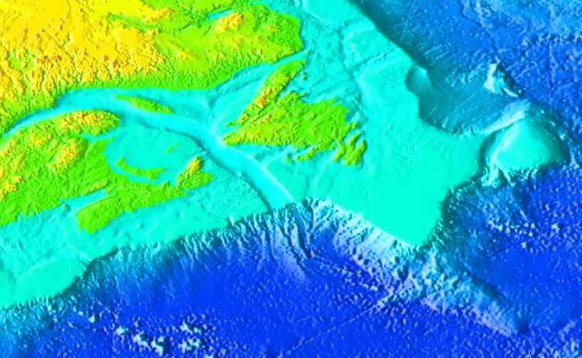
Mytilus Seamount. The map is "clickable" - and you can zoom in - see if you can find their location on the map!

The black and white is a terrific piece of WHOI history. It shows Broda's early days of coring. Here's how he explained the photo to me: "...taken at the mytilus seamount with a device that we cobbled together from old core pipe that we welded together on the fantail (we had "lost" all the other coring equipment) for added weight, we filled the barrels with all kinds of scrap rusty steel...shackles, chains, nuts and bolts. It was my first cruise and Charlie Hollister, for whom we named the long core, was the chief scientist."

I talked with Broda today about how he ended up immersed in WHOI's CDH Long Core technology and he explained that it was an evolution. His story wound along his journey to
today: astronomer dream deferred, college for aerospace engineering and then a switch to economic geology and finally a trip to the ocean for the first time. Wanderlust then - sustained by skiing and cooking - followed by a return to the sea, to WHOI. He was hired by Betty Bunce as a research assistant and worked his way up through the ranks at WHOI.

Again and again I hear similar stories from people at WHOI, "I was walking by an open door and someone offered me a job", "I was working on a project and this (world famous) researcher needed some help on a new (completely revolutionary) technology so I helped out", "I was free one summer and ended up on a research cruise where I learned to deploy underwater gliders".

You can read about Broda's remarkable accomplishments here and here too. What I really wanted to know from him was what critical incidents along his path directed him, motivated him, shaped his journey. But for Broda, it all blends; everything is relevant, all the projects served their purpose to challenge, prepare, develop, hone his talent, ideas, skills. From work with Mike Purdy and NOBEL to the spectrum of piston-cores gone-by, from the 100 research cruises to Charlie Hollister, in fresh water and in salt water. For nearly 40 years Broda has worked on land and sea pushing the frontiers of exploration and science.

Meet Amy

Amy Simoneau, of the Shipboard Science Services Group (SSSG), has lived all over the east coast and traveled all around the world! Amy's role is the critical link between the science
team and the R/V Knorr's crew. She's involved in collecting data with and maintaining the ship's scientific equipment as well as acting as the ship's system administrator. So you may think that Amy's academic background is in technology - but it's not. She's naturally tech savvy. Her academic background, work experience and natural talent combine to make Amy an enormously important asset for research aboard the R/V Knorr.

Towards the end of Amy's 12 years in her Catholic school system in New Hampshire, she was selected to participate in the Advanced Studies Program at St. Paul's School in Concord, NH. There Amy joined with her academic equals and spent a summer immersed in college-level courses and field work; her focus was on Ecology. The program was an excellent opportunity for Amy whose passions for social and environmental justice causes had already taken root.

After high school Amy attended UNH for Environmental Studies with a focus in Marine Science and did a Study Abroad Semester at Sea, SEA, then she headed south to Georgia after graduation. She landed a job working as a research technician for a coastal sedimentologist Clark Alexander at Skidaway in Savannah and then made her way back to the Northeast to where she worked for Boston College's Gail Kineke, whom she had met on a research cruise with Alexander. She also worked for the SEA program.

One of very large stumbling blocks for people seeking careers in STEM is simply not knowing what kinds of jobs are out there. By the time Amy got to Massachusetts, she had learned a great deal about research and cruises and, very importantly, about the spectrum of jobs that this kind of research created. Her first year working as an SSSG she spent her longest ship time to date: 5.5 months! - during which the ship traveled to Mauritius, one of her favorite places. (yes - do look for THAT one on a map!) Other favorites include Iceland, Chile and the Seychelles.

She has been an SSSG now for 10 years and loves it. She travels all over the world and she loves the challenges and the variety associated with working on a ship that hosts a broad scope of oceanographic science teams.

Life is good for Jim Broda and Amy Simoneau!

Jeff, Isabelle and Ancient Volcanoes

July 28, 2010

Lat/Lon: 39*33.47'N / 068*16.42'W
Air Temp: 25.8*C /78.44*F
Wind Speed: 12.66 kts
Humidity: 60.2%
Water Temp: 26.29*C /79.30*F
Salinity: 34.53 psu
Depth: 2888 m / 2.9 km / 1.7 miles


(I told Jeff and Isabelle to gaze out
pensively at the sea and
they did their best!)

Hi! Welcome to the New England Seamounts!
WHOI's fabulous Dina Pandya, tech Guru, has added a tool to our blog - "Expedition Updates By Location". It's at the top along the same line as "Home". Check it out!

Here's a youtube video taken by Alvin with footage of the organisms living on these seamounts.

The New England Seamounts were formed from plumes of magma upwelling from the mantle and through the crust called "hot spots". The Hawaiian islands have been formed
through the same process. The New England Seamounts are
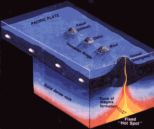
the longest seamount chain in the North Atlantic and, though theyare no longer volcanically active, they are still a prominent feature on the Sohm Abyssal Plain extending 1,100 km from Georges Banks to Bermuda Rise.

The hot spot responsible for these dramatic ocean floor features didn't only affect the seafloor. Just as the Atlantic was opening, part of the breakup of Pangea, this hot spot was first under the northwest area of Hudson Bay, and tracked under our North American continent, feeding the magmatic intrusions of our White Mountains. Still the hot spot was active and as the continents spread further apart, the hot spot tracked under the seafloor, forming these New England Seamounts. Amazingly, the mid-Atlantic Ridge also tracked over the hot spot and still it persevered. Evidence of this same hot spot is on the African Plate - the "Great Meteor Tablemount" - a guyot!

See on-board Chemistry teacher Bob White's blog for an explanation for WHY our Chief Scientist is so interested in these seamounts!

The photo at the top of this blog shows Jeff Hood, tannest man on the ship, and Isabelle Gil, who wins the award for being able to speak the most languages. Here's a bit about each of them.

Jeff Hood

Jeff Hood, Cape Cod born, is currently a Lead Mechanic at WHOI where he repairs and fabricates oceanographic equipment when he’s on land. At sea, Jeff is a coring technician who specializes in the amazing CDH Long Core. Jeff, following in his father’s footsteps, joined the Air Force after high school where his mechanics savvy was quickly identified and developed. He was stationed at Castle Air Force Base in California and in addition to learning mechanical skills that would lead him to his current career, he had the chance to travel extensively throughout much of the world. It was a terrific opportunity!

Jeff returned to the Cape after his time in the Air Force and while putting his mechanical skills to use began to add welding to his repertoire. After some time working at various shops on the Cape and a tour during Desert Storm, Jeff was offered a position working at WHOI. Now, happily settled on the Cape with his wife Annette and his 8-year old son George, Jeff loves his work because he gets to work on cutting edge technology with some of the best engineers in the world. When I asked him what he likes the most about being at sea I wasn’t surprised when he said that he loves the challenge of having to “make do” with what you have on the ship. “You can’t run out to the ‘parts’ store when you’re at sea.”

Isabelle Gil

French researcher Isabelle Gil started out her academic life at Pantheon Sorbonne University interested in coastal geomorphology but exposure to the world of research drove her to change direction. For Isabelle, the new path was in the growing field of paleoclimatology. Today Isabelle has a post-doc working jointly for LNEG, the Portuguese National Laboratory for Energy and Geology and WHOI where she studies diatoms present in cored marine sediments from the North Atlantic to gather data about paleoclimates.

Isabelle chose to do her research practical abroad, studying coastal geomorphology in Brazil. Once in Brazil she learned that there was no funding available to analyze beach rocks but the group at the Federal University of Rio de Janeiro offered her the opportunity to learn about coring, sampling and studying diatoms from the coastal lagoon (click here for non-satellite map). At that point her education had been preparing her for a vocational degree but she was introduced to the world of academic research and she was hooked! She returned to Europe to continue working on these cores, completed her DEA at University of Bordeaux I and moved on to study and write about diatoms in ocean cores for her Ph.D at Bremen University in Germany. One of the cores she worked on for this degree was from the Laurentian Fan (sound familiar?) sent to her by our Chief Scientist, Lloyd Keigwin! Now Isabelle will return to Lisbon and start digging in to all the samples she has gathered from the Western Atlantic. This paleodata will be used in climate modeling. Her favorite part about being at sea? “It’s great to see how the work is done – it really balances the time you spend behind the microscope and writing up papers. It’s the fun part!”

Sarah, Marti and the Gulf Stream

July 27, 2010

Lat/Lon: 39 ° 23.1690 N/067 ° 00.7036 W
Air Temp: 24.3*C /75.74*F
Wind Speed: 8.89 kts
Humidity: 57.7%
Water Temp: 26.81*C /80.25*F
Salinity: 34.51 psu
Depth: 4138 m /4.1 km /2.57 miles


WOW! Check out that water temp! Anyone care to guess what current we're running?

Today we are seamount hopping, trying to locate the best spot for mud. So today seems like a great day to introduce you to some of our amazing science team members! Meet Marti Jeglinski and Sarah Schulenberg

Sarah Schulenberg, Graduate Student UNH

I stumbled into paleoceanography/paleoclimatology, to be honest. I earned a Bachelor’s degree in chemistry at a small state university and began to realize towards the end of that track that I wasn’t entirely sure what I wanted to do. I had begun to hear about graduate school from professors and teaching assistants. It sounded like a good deal: they pay your tuition and fees and pay you a stipend to teach or do research, all while earning a degree that may earn you more money in the end. At least that is how it translated into my mind.

Around the same time, I had learned about a melding of disciplines known as geochemistry. I began the search for graduate programs in geochemistry, not knowing that was about as ambiguous as saying a degree in chemistry.

I ended up being accepted into the graduate program in the Jackson School of Geosciences at The University of Texas at Austin. I was put under the advisement of a faculty member interested in hydrogeology and geomicrobiology.

I was not enjoying my course work or the possible avenues of research that were being talked about for me. I decided to visit some of the other faculty in the department and find out about their research. I found a faculty member who was interested in paleoceanography and paleoclimatology. When I told her I was not a geologist, she caught me with a line that I remember still, “Oh, I never consider myself a geologist. If I had to classify myself, I would say oceanographer or chemist.” I switched advisors and began to enjoy my courses so much so that I switched from pursuing a Master’s degree to the PhD track.

I am not always convinced that I will be able “to hack it” but I am doing my best to enjoy the education I am receiving. I am also continually meeting people that help me to understand what I am now or may be capable of. I have since followed my advisor from Texas to the University of New Hampshire because I wanted to continue to work under her as I pursue my PhD.

In the fall of 2009, my advisor received an email from her former PhD advisor that extra hands were needed on a marine sediment cruise in the beginning of 2010. I immediately agreed not only due to my lack of field experience but also for the chance to experience the open ocean. A free trip to Bridgetown, Barbados was a nice perk as well.

While out at sea, I threw myself in wholeheartedly, jumping in where- and whenever needed. I wanted to learn and absorb as much as possible. Apparently, I made an impression because they asked me to come back out with them on this leg. It is certainly not all roses and sunshine everyday while out at sea but the work is satisfying to me. So few people see this side of science, the dirty side. A lot of grunt work goes into publishing those pretty, glossy scientific papers and I feel beyond grateful that I have been given the opportunity to experience it.

**************************************************

Marti Jeglinski, Research Assistant WHOI

Have you been to the Azores or Barbados or the Santa Barbara Basin? How about Bahamas, Panama Canal, Bermuda Rise or the Florida Straits? Perhaps Senegal or Iceland - all by ship? It’s time you meet Marti Jeglinski.

Cape Cod born Marti Jeglinski graduated from Salem State with a degree in Earth Sciences in 1977 and was hired by the United States Geological Survey back on the Cape. By 1979 Marti was hired by Charlie Hollister (yes the same one after whom the long core was named!) as a research assistant at WHOI. It was the start of career in scienc

e technology and research at WHOI spanning more than 30 years and still going. In the course of her career Marti married a Merchant Marine Chief Engineer Jim Jeglinski and had two sons who are now in their 20s. Her husband was at sea 6 months a year which made for quite a juggling act.

Marti’s interest in the sciences was piqued by a geology professor at Salem State. It was enough to pull her from her Education degree program and she hasn’t looked back since. At USGS and WHOI Marti worked with researchers in paleoclimate, physical oceanography and hard rock marine geology. She has run the mass spectrometer lab, maintained a benthic foraminifera culture lab, constructed and tested floats for physical oceanography studies, worked on mapping of the Kane Fracture Zone, an analyzed cores for forams.

Last year Marti was the recipient of the Linda Morse Porteous Award. I thought that it would be great for you to hear some of the remarks that were written by Marti’s colleagues and shared at the awards night.

“Even after long, hard hours of deck work you can count on her irrepressible spirit to

pick you up and get you through whatever challenge confronts you... she works tirelessly,

looking after everyone, cares passionately about getting all the goals of the cruise done

and done well, and does so with grace and a big smile on her face. As I have always said,

‘I want her in my lifeboat.’ ”

“From laboratory work, tedious at times, to production work, she has made modifications

to equipment, designed tools and fixtures for tasks that have been performed inefficiently

for years. She would tell me, ‘Just because it has always been done like this doesn’t mean

it’s the best way to do it.’ For instance, when she was working in the Float Group there

was a procedure of stretching a rubber bladder and wrestling it onto a pressure case. This

procedure requires tremendous physical strength... after she successfully installed a few

bladders she designed a tool to stretch these. A task that was once dreaded became so

simple that anyone could do it and it doubled the daily output.”

“She always finds the positive side of a difficult situation or person. She always finds

time for those in need, expecting nothing in return. She makes us all comfortable and at

ease in a difficult work environment.”

“She effectively conveys seemingly complicated and complex scientific notions, even to

those without a scientific background. Once while box coring in rough seas, the marine

technicians from Scripps did not understand the importance of recovering deep-sea

sediment samples in stratigraphic order. She used an analogy of ripping pages out of a

book, mixing them up, and then trying to interpret them. They immediately understood

and for the remainder of the trip the technicians were cautious when recovering material.”

When describing experiences with being out to sea with the awardee, one nominator said,

“She’s there for you when you cut yourself, she has remedies for just about whatever is

ailing you, and she will laugh along with you during the most trying times.”


Pretty amazing women, wouldn't you agree?


From Space to the Seafloor

July 26, 2010

Lat/Lon: 41°59.68'N /063°11.83'W
Air Temp: 19.9*C /67.82*F
Wind Speed: 27.45 kts
Humidity: 68%
Water Temp: 21.35*C /70.43*F
Salinity: 32.53 psu
Depth: 2510 m /2.5 km / 1.55 miles


Chief Mate Matt McInteyer on the bridge

Our 8 hour transit ended with a knock on the door at 12:30 am waking us for a gravity core. As it turns out we had a bit of a wait as there was yet some surveying to complete at Sable Island. The gravity was followed by a 2:30 am multicore and a 4 am long core.

One of the most amazing technologies I have come across on this research cruise is "DP" - Dynamic Positioning. Anchors just don't cut it out in the deep ocean. It is this technological marvel that allows the science team to safely and effectively core the ocean floor.

The photo to the right is from earlier in the cruise but I'm using it here to emphasize the importance of the DP technology. The gravity core pictured in this photograph strikes me as so very thin and fragile (of course when you're hefting that core full of mud and your team is working to move it, it doesn't feel quite so fragile!) It is vital that the ship maintain it's position so the coring equipment is not damaged.

Since the launch of Sputnik in 1957 humans have been launching satellites into space for all kinds of reasons. Today there are hundreds of satellites orbiting earth that are used as tools for things such as weather forecasting, monitoring the earth systems, communication and entertainment and navigation. The R/V Knorr uses satellites not only for navigation but also for maintaining position at coring sites.

The picture to the right shows the the controls for the R/V Knorr's three thrusters involved in the DP system: the top for the bow (900 horsepower) and the two sides for the port and starboard thrusters aft (each 1500 horsepower). The central control is the autopilot.

Waves and currents cause the ship to move in distinct ways: heave and yaw, roll and surge, pitch and sway. Sensors monitor and measure the amount of each type of motion and the DP system calculates the forces necessary to maintain a single position. Once the ship arrives at the desired location (for our cruise it's a coring location) the on-ship computer communicates with navigation satellites and identifies this location. After this has been set the on-ship computer constantly checks its location with the satellite and, factoring for the movements of the ship with the wind, waves and currents, adjusts the thrusters as needed to maintain the desired position.

Just amazing!

Chief Mate Matt McInteyer (pictured at the top of today's blog), former ship captain for the American President Lines (APL) which is a top container transport and shipping company in the world, spent time explaining the R/V Knorr's technology and the ins and outs of their daily routines. He explained that there are such differences between the R/V Knorr and the 900+ft barges he sailed for the last 20 years. One of the big differences is the motion of the ship. He said that on those barges there needs to be a LOT of wind and wave action for you to feel any motion on those big ships. Here on the R/V Knorr the constant motion is exhausting. This, of course, made us feel better because we're all ready to lay down and sleep whenever we get the chance!


After several days of listening to the fog horn I was anxious to learn about how they could navigate the boat through the thick fog. The picture to the left shows our ship (brightest spot) and a barge just to the left (the smaller bright spot) on a radar screen. See the picture below for a visual of the same barge - red on the horizon.


This barge may look quite far off to you but to us it looked way too close for comfort after we've spent two weeks at sea with only one other ship sighting!

We're off to the New England Seamounts


Ah! Thanking my lucky stars - it's Sunday!

July 25, 2010 Sunday Funnies


Lat/Lon: about halfway north and mostly west

Air Temp: uh...i thought this cruise was supposed to be warm!

Wind Speed: less than a gale, more than a breeze

Humidity: not that bad, eh?

Water Temp: you wouldn't last long

Salinity: I'll check that out the next time water
splashes over the deck

Depth: 147,677 inches / 3,624,000 mm / 0.75 leagues

I fear a bit of seasickness has struck my innards so I was enormously grateful, as I balanced myself in the shower this morning against the heavily pitching boat, that today's blog is the Sunday Funnies!


(above) It seems that at least one member of the science team has
lost his head in the excitement of the trip!


(above) Secret Lives of Scientists: Arts 'n Crafts Hour
Clear indicators that we are on a
"watch" schedule
(two pictures below)


Working hard? Or hardly working? (above and
below)


We're off to Sable Island - tune in for our next episode of Mud Hunters!

The Laurentian Fan

July 24, 2010

Location: Laurentian Fan
Lat/Lon: 43*27.87'N / 054*45.34'W
Air Temp: 18*C / 64.4*F
Wind Speed: 18.12 kts
Humidity: 92%
Water Temp: 16.86*C /62.4*F
Salinity: 32 psu
Depth: 3983 m / 4 km / 2.5 miles


Today's afternoon-evening schedule is busy so it's great that we had a full night's rest. This morning we woke up to a clear blue sky with only wisps of cirrus clouds. The water was beautiful green-blue and the air felt crisp "like fall" I kept hearing people say - and I agreed.

Now, in the afternoon, we have more haze on the horizon and some altostratus cloud cover and we have arrived at the "Laurentian Fan" where we will sample on into the night after some initial surveying. Our schedule is detailed on the white board in the picture at the top of this blog entry. There will be a full suite of coring: Gravity, CDH Long Core and Multicore.

The ocean floor in this area is very interesting. We are no longer out in the middle of the ocean. We are close to the land, in the region of the "continental margin". Continental margins have distinct regions labeled here; they are the boundary regions between thick continental crust and thin oceanic crust. Gravity rules so continental margins are covered in sediments that have been eroded from the land and carried downslope to the ocean. Rivers are often the mechanisms that bring sediments from the land to the continental margin but wind and glaciers can also contribute (as well as their icebergs).

I really like this image. It shows the continental margin with a particularly notable east coast submarine canyon carved out by the flow of the Hudson River after the stream enters the ocean. If your geography is pretty good you may be able to pick out Cape Cod & the Islands, Long Island and Chesapeake Bay!

While much of the energy from the river dissipates as it hits the ocean (like when you are sliding down a water slide and hit the pool - you slow WAY down!), there is some energy remaining that carves a path along the continental shelf and down the continental slope and rise called a "submarine canyon". Here is a famous submarine canyon, in California. Note the extension of the river into the ocean.

Submarine canyons are unique biodiversity "hotspots". My dad, a former lobsterman, explained to me that you find the real big lobsters in these canyons. All over the world these canyons habitats teeming with life!

As with most canyons, water flowing through them will erode sediment from the sides and bottom and deposit it at the outlet of the canyon creating a "fan". Check out this image and find the "abyssal fan". You will see the same kind of feature in arid high relief environments subject to flash floods, pictured here. The submarine fan we will be coring is called the "Laurentian Fan". It was fed by the Laurentian Channel, carved by a tongue of the Laurentide Ice Sheet during our last Ice Age.

I can't believe I found images of the area! Click here for a closer look at the map to the right - find site "15". We are currently sampling on the east side of the main channel, just to the right and down the slope of the "15" on the map.

Here is an unlabeled map of the same area. When you open it you are looking at the continental margin of southeastern Canada. The St. Lawrence River enters the image from the far left. Note the Laurentian Channel. Go to your browser menu tray and see if you can find "zoom" to zoom into the region of the map where the Laurentian Channel is continued down the continental slope to the fan on the sea floor. This is where we are sampling!

The sediments that compose the bulk of the Laurentian Fan are glacial. Check out this site for a terrific sequence of images detailing the of events as the Laurentide Ice Sheet was retreating. Note that the website starts with the oldest time at the top and as you scroll down it becomes increasingly more recent.

An earthquake can cause the sediments deposited in a submarine canyon to shake loose and tumble down the continental slope (slope failure), churning all the way down. These churned up sediments come to rest on the ocean floor. Researchers like Keigwin are not interested in these deposits, called "turbidites", because they no longer preserve the chronological rock record of the ocean floor. So it's not the actual glacial sediments that are of interest to this science team.

Instead, this science team is interested in the deposits that sit on top of these turbidites made up of the glacial sediments. The Deep Western Boundary Current, known as the "Western Boundary Undercurrent" in the Atlantic Ocean, flows north to south along the western edge of the North Atlantic. It carries and deposits marine sediments (including the very foraminifera plankton we've been gathering from the ocean floor since the Azores) . Note that it flows in the opposite direction as the Gulf Stream. This powerful undercurrent is responsible for a remarkably high deposition rate at the Laurentian Fan. If you recall, the average deposition rate for the North Atlantic deep ocean is ~ 3-4 cm/1000 years. On the continental margin the deposition rates are higher - there are rivers draining the land, depositing sediments all along the continental margin. So the average deposition rate along these continental margins is ~ 10 cm/1000 years.

The deposition for this particular section of the continental margin, the Laurentian Fan, is

get ready for this -

40 cm / 1000 years

No kidding.

Dead serious!

No wonder Keigwin is interested in this location! There's TONS of mud!


Okay - I've totally bombarded you with geology! So the last thing I'm offering you here is an image of ice. Here's an image of North America during our last Ice Age. Note the solid white line marking the furthest extent of the Laurentide Ice Sheet - on the east coast, it extended all the way down to Long Island! That island is a "terminal moraine" - a strip of rocks and sediments left behind as the ice sheet melted ("retreated"). The Laurentide Ice Sheet is thought to have drained south along the Mississippi River to the Gulf of Mexico, east through the Hudson and St. Lawrence Rivers to the Atlantic Ocean and north through the MacKenzie River to the Arctic Ocean. Look carefully at the image. You can see the river called the "Mackenzie" draining north to the Arctic Sea.

The end.


A long day

July 23, 2010

Lat/Lon: 42*38.42'N / 051*12.18'W
Air Temp: 17.6*C / 63.6*FWind Speed: 20.31 kts
Humidity: 83.7%
Water Temp: 15.29*C /59.54*F
Salinity: 31.84 psu
Depth: 2033 m / ~2 km / 1.24 miles

From left to right: Tom, Chris, Sarah, Marti and Frank

All dressed in buoyant and highly visible clothing, the second-watch crew braved the rain, the wind and the enormous waves to complete gravity cores today. A multi core was done once the weather calmed down a bit and a long core was also completed.

Ah - do forgive the brevity of this blog entry. It has been a long day of coring, balancing and waiting.

The day started out cold, foggy and rainy. I have to share that my grasp of temperatures in degrees celsius has vastly improved given that the blog reports temperature in both
units and our European researchers need it in celsius in conversation. The water temperature listed above is literally 10*F warmer than it was for the entire day. It was so foggy you could see very little in any direction. Several times throughout the day the sky cleared and the sun warmed our faces. But for the most part it has been cold, raw and difficult to stand, for the waves.

We saw more pilot whales! Up to four dorsal fins making their appearance at once. They stayed clear of the R/V Knorr but the hung around riding the huge
swells for quite some time. They were just amazing to watch!

Sarah and Tom are pictured to the right in the "man-basket" feeding bullets down the long core to push the core liner out way at the other end of the boat. I wish you could understand what a feat their nerves allowed them to accomplish. They were hanging way out there in all this weather and in all those waves. After waves pass under the
boat, Sarah and Tom had their feet pretty much in the water!

The segment of the gravity core driven the deepest into the sediment is referred to as "Section 1". When Section 1 was opened today - peeeeeyouuuu! the stink! All kinds of jokes were made - but the bottom line is that all that stink came from the breakdown of lots of life. This is a distinctly different biological environment than the ones we have been in to date.

The picture below is terrific! It shows segments of the long core with red tops that are stretched to their limit with gases in the sediment! They're nearly bursting!

Expert Nick McCave told us not to hang out around these cores -they could burst out of the casing! As it is the chief scientist had to go around to each of them stabbing holes to relieve some of the pressure. If you look closely at the picture to the right you'll see mud oozing out of the middle red-topped core - messy, smelly work!


Right now the boat is heave-ho-ing. More than one person has squeaked a "good night"
before crawling to bed. Everything has been tied down, the doors are dogged and we have an 18 hour steam ahead of us. That means a good, long rest for this tired crew!


Western Atlantic - Hello Labrador Current!

July 22, 2010
Lat/Lon: 42* 57.0595 / 048* 10.9752'
Air Temp: 18.6*C / 65.5*F
Wind Speed: 12.58 kts
Humidity: 94.1%
Water Temp: 14.86*C / 58.75*F
Depth: 3285m /~ 3.3 km / 2.05 miles

It is CHILLY!!! Visibility is low, obscured by low clouds. The water temperature dropped 6 degrees in the course of one hour! Long sleeve shirts and raincoats are in order. Hello Labrador
Current!

With the fog horn sounding, we continue steaming north.

During the 5:30 am multicore drop the science team spotted a pod of beautiful pilot whales! We've also been seeing Leach's Storm Petrels flying and landing on the boat here and there. (As an aside, the site linked for the Leach's Storm Petrel seems to be a really terrific bird ID website.)

Here is another map that gives you a better idea of where we are located. Open the map and find, "Northwest Atlantic Mid-Ocean Canyon". We are located approximately just south and west of the "O" in "Ocean", in the Newfoundland Basin. When we begin our return home along the east coast of North America it is the Labrador Current that we will be riding home.

Right now we're in a cycle of steam northwest-multicore-steam again-multicore. There are some gravity cores in there too. We've stopped the formal 2-watches and we're now going to have a posted schedule and be sure that all coring events will be adequately staffed.

Yesterday the blog covered the logistics of sampling and processing the muds from the cores. In addition to that process, the cores are run through the "Geotek Logger". I love their logo: "If it's worth coring, it's worth logging..."

The science team uses the Geotek Logger to gather two parameters: "Gamma attenuation"
and "Magnetic susceptibility". In the picture to the right I am standing next to the Geotek Logger with Ricardo, Sarah and Kathryn. You can see two white PVC sections (core segments) full of mud on the track. We're running Long Core segments here. The top of each core has a red cap and the bottom has a black cap. Both are sealed with electric tape to prevent the mud from dripping out.

Look carefully at the image. Between the two core lengths there is a yellow "radioactive" sticker on a lead container in which the chunk of radioactive Cesium-137 is housed. Gamma rays are sent through each mud core sample and detected on the other side. Because gamma radiation is extremely damaging to human tissue the direction of the beam is to the outside of the boat where there is no walkway so no one will be hit with the radiation; it is an important precaution.

The Geotek Logger is a very useful tool to have on the ship. It is a unique data gathering tool because it is "non-destructive". Once the cores are brought to the WHOI labs they will be cut in half (lengthwise) into the "working" and "archive" halves. At that point the researcher and his/her team dig into the "working" side. The archived half is sent to the archive repository and will serve as the record of findings. After months / years of investigating the core, the "working" side has been really picked over so the core has, essentially, been destroyed.

The gamma attenuation is used to measure the density of the mud in the cores. Gamma emitted from the source (Cesium-137) passes through the mud in the core and a portion of the gamma ray are scattered. The gamma rays that were not scattered pass through the core sample to the detector on the other side. Higher density materials in the core segment increase the scattering of the gamma rays, thereby decreasing the amount of gamma reaching the detector. Gamma ray scattering is lower when the density of the core materials is lower allowing more gamma rays to reach the detector.

Take another look at the picture at the top of this blog entry. Gamma attenuation is in yellow on the left. Look carefully - do you see "spikes"on the graph? They were created by the plastic covers and air between two core segments.

The other parameter measured with the Geotek Logger is "Magnetic susceptibility". This is represented by the green line on the picture at the top of this blog entry. As the core segment is pushed down the track, it first encounters the gamma rays and then a magnetic field. In the Geotek logger picture above, notice the white rectangle with a round opening for the core to pass through. It has a red support strap holding it in place. A magnetic field is generated in the ring. If the material within the core is non-magnetic the sensor will detect a weakening of the magnetic field. If the core material passing through is magnetic - even only somewhat - a strengthening of the magnetic field is detected.

So why are some of these muds magnetic and others not?

This question is remarkably complex. The basic sources of magnetic materials are from volcanic materials and land materials. Volcanoes emit varying degrees of iron-rich matter which can flow or be blown over the ocean, settling to the sea floor and adding to the sequence of sediment there.

Land materials are introduced via rivers, wind and icebergs. The icebergs are particularly relevant for this research cruise as they are particularly climate dependent. When there is a great deal of ice on the planet, icebergs, laden with mineral fragments from the land, drift with the ocean currents, melting and dropping the small rocks
into deep ocean water. Climate scientists refer to these as "IRD"s: Ice Rafted Debris, . They are distinctly different than other deep ocean sediments because they tend to be larger and angular. Once free from the ice the rock fragments settle to the sea floor atop other marine sediments and are buried by more marine sediments.

The marine sediments that the chief scientist is looking for are the remains of tiny organisms that once lived in the upper regions of the ocean. So while he's not particularly interested in the sediments from the land, they do contribute to our understanding of Earth's climate past.

The picture to the right shows a pile of cores that were generated from only one Long Core sampling event! They're strapped down to prevent them from getting too carried away with the motion of the ocean! Right now with our coring and transit schedule, much of the logging on the Geotek will be done while we are underway so we need to be extra careful that the cores are tied down!


Lab Rats

July 21, 2010
Lat/Lon: 40* 18.006'N / 48*27.9988'W
Air Temp: 23.9*C / 75.02*F
Wind Speed: 15.85 kts
Humidity: 87.1%
Water Temp: 24.71*C / 76.50*F
Salinity: 34.8 psu
Depth: 3835 m


Day 2 of working with 2-shifts of watches. It looks like the CDH Long Core is going to go down today! Hurrah! The gravity core went in on our shift just after 3 am and when it was time to bring it back in the boat we were delighted to see not only large chunks of floating seaweed but a big school of fish - each fish measuring about a foot long. There was lots of activity. Some fish were skittering above the crowd, just at the surface. We figured that we weren't the only ones watching the school...

Today I thought we could move inside the R/V Knorr to start covering all that goes on in the labs.

When each of the cores are brought to the surface and then into the boat, samples of the mud are gathered from each cut segment of the cores. In the picture below you see some of the sampling bags. Preparation for sampling is crucial because it can hold up the entire process of
cutting, capping, sealing and moving the cores if the sampling tools are not ready. Each sample bag is named for the cruise, the leg, the core type, the sampling event and the location of the sample relative to the entire core:

- KNR 197-10 (R/V Knorr Cruise 197, Leg 10)
- CDH 2 (CDH Long Core, Sampling Event #2)
- BOT 2 (bottom of the second section of the core)

I know I mentioned this in an earlier blog entry but it's relevant here too - in the gravity core you'll have about 4 sections of core and in the long core you could end up with up to 26 sections of core. Each segment is about 1.5 meters (~5 feet).

At the top of this blog you see Isabelle Gil, French researcher working in Portugal. Her research is focused on different fossils organisms than those the chief scientist is interested in - however, those she studies, called "diatoms", are found in the very same cores in which Keigwin finds his foraminifera. Gil is pictured at the top sampling the bottom of a segment of the long core. In her hand you can see the labeled sample bag and a spatula. She has to be careful how much mud she scrapes from the core because, if you recall, several centimeters represents hundreds of years - even
over one thousand years depending on the particular site. Gil samples for chief scientist Keigwin and for her own research.

In deep marine environments the size of particles that land on the ocean floor tends to be very small. For this reason, a very fine sieve (63 microns), pictured right, is used to separate forams and diatoms from the fine muds. The fine muds from the samples "washed" on the ship are captured in a bucket and tossed overboard. When the samples are washed at Woods Hole the muds are kept and studied to provide information about settling rates. This gives researchers a better idea of how fast / slow sediments are settling on the bottom. This kind of data is vital because it provides a framework for how much time is associated with a set thickness of sediment. The average rate of seafloor deposition in the North Atlantic is 3-4 cm/year. The North Pacific is significantly less. Check out this image of the thicknesses of ocean floor
sediments. I LOVE maps! And this one is particularly cool! Look carefully at it - find the scale.

Why do you think certain areas have significantly more sediment than others?


The bags pictured left give you an idea of what the mud samples look like before they are washed.

After "washing" the muds, all that is left is the forams and some diatoms, pictured right in filter paper.


They are then dried in the lab oven and poured into carefully labeled
vials. Paola Moffa Sanchez, PhD researcher, is pictured to the right "picking" forams. Marti, Kathryn, Sarah and Isabelle all work with Paola to pick the forams.

Notice that she has a gridded black tray. She has poured the dried sediments from one vial onto the black tray so she can study them. The grids facilitate the process of identifying and counting the forams. Quantity and identity of the foraminifera can tell researchers a great deal about the history of the ocean and climate!

More to follow on R/V Knorr labwork!


First morning on Second Watch

July 20, 2010
Lat/Lon: 40 ° 25.5815 N / 047 ° 15.6313 W
Air Temp: 24.5*C /76.10*F
Wind Speed: 14.48 kts
Humidity: 85.6%
Water Temp: 42.12*C / 75.416*F
Depth: 3683 m / 3.7 km /2.3 miles


Today we rose at 12:15 am.

Waking in your stateroom you have no sense of day or night, of the temperature outside - no sense for whether the sun is brightly shining or if it's covered by clouds - no sense of anything other than the cool constancy of your room. Even the sound doesn't really change - loud, pulsing and also constant.

The decision was made to switch us to 12 hours shifts midday yesterday so the 1pm to 1am first-watch started up right away and we, the second-watch, headed to bed last night earlier than normal but too late, we knew, to be genuinely functional at the start of our shift. Or the middle of our shift. Perhaps not even towards the end of our shift!

A hot shower revives you some (if you rise early enough to hop in) and you don your muddy clothes from yesterday (from several hours ago), shuffle down the hall and climb up one flight of stairs. You survey the lab. People are about but solitary in their seats; first-watch people have been sitting for several hours willing themselves to stay awake and second-watch people can merely blink in the bright lights of the lab. The boat rocks forcefully. You look to the portholes for some sense of the horizon but only inky blackness is visible, for it is the
middle of the night and we are steaming ahead.

Our first site is reached within an hour of our shift start and suddenly nearly everyone on shift is dressed in hard hats and bright orange flotation vests.

Tasks are welcome.

Lines are in hands, someone has climbed up into the crane. Sarah thought she saw a bird but then perhaps it was the white cap of a wave looming high enough to be mistaken for something in the sky. Time to launch the multicore. The log has "Tip of Grand Banks" written on the LOCATION line, so that's where we must be. I think of fishermen hundreds of years ago rowing, rowing away from larger boats, fishing the Banks, returning with their boats full of cod, some not returning at all. If the R/V Knorr is pitching in these waves, what must it have been for them?

Back in the lab we turn our computers on, we all check our emails and Facebook pages and laugh at ourselves realizing that we only logged out of them four hours earlier. I begin searching for the time of sunrise on the Internet, as it is the sunrise that everyone reminds you of when they see you're on second watch: "Oh - that's hard! But you get to see the sunrise!" It's surprisingly difficult to find as my primary point of reference is the Mid Atlantic Ridge.

Ah - Greenland! No data. Ah! Brazil! Ah - forget it. We'll see it when it rises.


Several quiet hours pass and it is time for the multicore to surface. We step out onto the deck into a sunrise obscured by haze and clouds. A bird is on the deck, hobbling away from us as we try to help it (help it to do what? we weren't sure). One foot was webbed, the other...I think it was gone. The multicore is brought up from the sea, the second-watch team pulls it apart and we set up for archiving and sampling the small cores.


By the time we are working with the mud, the sun is visible, a bright luminous
sphere, burning above the strip of haze along the horizon.

The day has begun.