
July 24, 2010
Location: Laurentian Fan
Lat/Lon: 43*27.87'N / 054*45.34'W
Air Temp: 18*C / 64.4*F
Wind Speed: 18.12 kts
Humidity: 92%
Water Temp: 16.86*C /62.4*F
Salinity: 32 psu
Depth: 3983 m / 4 km / 2.5 miles
Today's afternoon-evening schedule is busy so it's great that we had a full night's rest. This morning we woke up to a clear blue sky with only wisps of cirrus clouds. The water was beautiful green-blue and the air felt crisp "like fall" I kept hearing people say - and I agreed.
Now, in the afternoon, we have more haze on the horizon and some altostratus cloud cover and we have arrived at the "Laurentian Fan" where we will sample on into the night after some initial surveying. Our schedule is detailed on the white board in the picture at the top of this blog entry. There will be a full suite of coring: Gravity, CDH Long Core and Multicore.
The ocean floor in this area is very interesting. We are no longer out in the middle of the ocean. We are close to the land, in the region of the "continental margin". Continental margins have distinct regions labeled here; they are the boundary regions between thick continental crust and thin oceanic crust. Gravity rules so continental margins are covered in sediments that have been eroded from the land and carried downslope to the ocean. Rivers are often the mechanisms that bring sediments from the land to the continental margin but wind and glaciers can also contribute (as well as their icebergs).
I really like this image. It shows the continental margin with a particularly notable east coast submarine canyon carved out by the flow of the Hudson River after the stream enters the ocean. If your geography is pretty good you may be able to pick out Cape Cod & the Islands, Long Island and Chesapeake Bay!
While much of the energy from the river dissipates as it hits the ocean (like when you are sliding down a water slide and hit the pool - you slow WAY down!), there is some energy remaining that carves a path along the continental shelf and down the continental slope and rise called a "submarine canyon". Here is a famous submarine canyon, in California. Note the extension of the river into the ocean.
Submarine canyons are unique biodiversity "hotspots". My dad, a former lobsterman, explained to me that you find the real big lobsters in these canyons. All over the world these canyons habitats teeming with life!
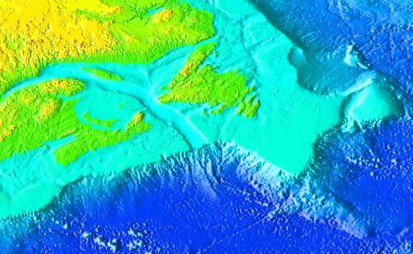
As with most canyons, water flowing through them will erode sediment from the sides and bottom and deposit it at the outlet of the canyon creating a "fan". Check out this image and find the "abyssal fan". You will see the same kind of feature in arid high relief environments subject to flash floods, pictured here. The submarine fan we will be coring is called the "Laurentian Fan". It was fed by the Laurentian Channel, carved by a tongue of the Laurentide Ice Sheet during our last Ice Age.

I can't believe I found images of the area! Click here for a closer look at the map to the right - find site "15". We are currently sampling on the east side of the main channel, just to the right and down the slope of the "15" on the map.
Here is an unlabeled map of the same area. When you open it you are looking at the continental margin of southeastern Canada. The St. Lawrence River enters the image from the far left. Note the Laurentian Channel. Go to your browser menu tray and see if you can find "zoom" to zoom into the region of the map where the Laurentian Channel is continued down the continental slope to the fan on the sea floor. This is where we are sampling!
The sediments that compose the bulk of the Laurentian Fan are glacial. Check out this site for a terrific sequence of images detailing the of events as the Laurentide Ice Sheet was retreating. Note that the website starts with the oldest time at the top and as you scroll down it becomes increasingly more recent.
An earthquake can cause the sediments deposited in a submarine canyon to shake loose and tumble down the continental slope (slope failure), churning all the way down. These churned up sediments come to rest on the ocean floor. Researchers like Keigwin are not interested in these deposits, called "turbidites", because they no longer preserve the chronological rock record of the ocean floor. So it's not the actual glacial sediments that are of interest to this science team.
Instead, this science team is interested in the deposits that sit on top of these turbidites made up of the glacial sediments. The Deep Western Boundary Current, known as the "Western Boundary Undercurrent" in the Atlantic Ocean, flows north to south along the western edge of the North Atlantic. It carries and deposits marine sediments (including the very foraminifera plankton we've been gathering from the ocean floor since the Azores) . Note that it flows in the opposite direction as the Gulf Stream. This powerful undercurrent is responsible for a remarkably high deposition rate at the Laurentian Fan. If you recall, the average deposition rate for the North Atlantic deep ocean is ~ 3-4 cm/1000 years. On the continental margin the deposition rates are higher - there are rivers draining the land, depositing sediments all along the continental margin. So the average deposition rate along these continental margins is ~ 10 cm/1000 years.
The deposition for this particular section of the continental margin, the Laurentian Fan, is
get ready for this -
40 cm / 1000 years
No kidding.
Dead serious!
No wonder Keigwin is interested in this location! There's TONS of mud!
Okay - I've totally bombarded you with geology! So the last thing I'm offering you here is an image of ice. Here's an image of North America during our last Ice Age. Note the solid white line marking the furthest extent of the Laurentide Ice Sheet - on the east coast, it extended all the way down to Long Island! That island is a "terminal moraine" - a strip of rocks and sediments left behind as the ice sheet melted ("retreated"). The Laurentide Ice Sheet is thought to have drained south along the Mississippi River to the Gulf of Mexico, east through the Hudson and St. Lawrence Rivers to the Atlantic Ocean and north through the MacKenzie River to the Arctic Ocean. Look carefully at the image. You can see the river called the "Mackenzie" draining north to the Arctic Sea.
The end.

No comments:
Post a Comment