
July 14, 2010
Location: West of the Azores
Coordinates Lat / Lon: 37* 13.949'N / 37* 27.0753' W
Air Temp: 22.9*C /73.40*F
Humidity: 81.2%
Sea Surface Temp (SST): 24.81*C / 76.66*F
Salinity: 30.07 psu
Depth: 3435 m / 3.4 km / 1.34 miles
We were told today that we will be steaming westward for two days and then surveying in the new location. The hiatus in sampling allows the science team to spend time looking at the data, talking and planning. The picture at the top right shows (clockwise from top) retired MA teacher Frank Scofield, OSU faculty research assistant Paul Walczak, OSU senior faculty research assistant Chris Moser, Spanish PhD researcher-living- in-Wales Paola Sanchez, French researcher Isabelle Gil, British marine geochemist Nick McCave, Chilean paleoceanographer Ricardo De Pol-Holz, and Ameican chief scientist for the cruise, WHOI's Lloyd Keigwin. They had crowded around Nick as he explained the subsurface imagery he was looking at on his computer.
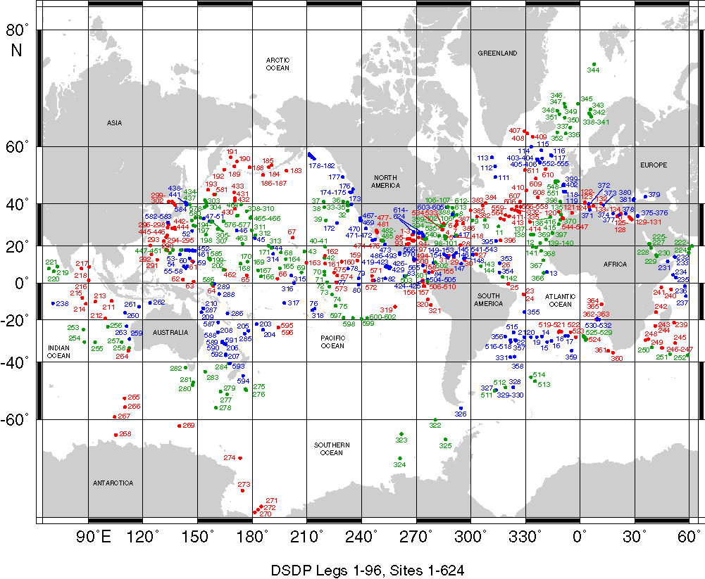
So where to now? Check out this map. We're transiting to Deep Sea Drilling Project site #606 ("DSDP 606"). As you look at the map remember which ocean we're currently in the middle of! If you were a researcher, where would YOU want to go to do some coring? You can click on the image to zoom a little. You are looking for "606" and I'll give you a hint: it's in red font.
It is very interesting yet seemingly impossible to me that every little detail of the research cruise is not set in stone. There are, of course, locations to which Keigwin plans to travel as we make our way across the ocean; these are largely based on data

from the few research coring cruises and many mapping cruises in the area. Keigwin's team was deliberately assembled to have experts in the sciences and technologies included in this effort. But sampling decisions are made daily, based on remote sensing surveys, gravity cores, and weather. We have been lucky enough to have good weather to date (kindly knock on wood
wherever you are!). The picture to the right shows the fruits of WHOI research specialist Steve Swift's labor - high resolution imagery of the sea floor.
At each sampling site a gravity core is done first. This gives the team an idea of the nature of the sea floor and subsurface. While it is a standard method for sampling ocean floor it is also a key tool for researchers to use to determine whether or not it makes sense to drop the long core down. The giant gravity corer, in essence, acts as a scout for the long piston core. This may not be the case in all cruises, of course.
Keigwin's team is coring low relief (relatively flat) regions along the Mid Atlantic Ridge. Others in the oceanography community have chosen to ignore these areas, asserting that there are only volcanic materials there. (recall that this cruise is focused on gathering sediments/muds from the ocean, not lava). "How do you know there are only volcanics there?" he has asked them. And, as he received no satisfying answers, he decided to go forward with the investigation.
It's a good thing he is too - for these regions could potentially be excellent locations to gather marine sediments. For Keigwin and his team, it's not just about the "what" they are gathering, it's also about the "where" and the "how".
This map (starting in top left corner, count 4 from left and go down to the second from the top to find Azores) is clickable so you can REALLY zoom in. As long as your mouse cursor shows you a magnifying glass with a "+" sign, you can zoom in more! Keep in mind that new volcanic material is being ejected out from parts of the Mid Atlantic and that the Azores are volcanic.

The corrosive saltwater and air keep the R/V Knorr's crew busy! Joe and John, pictured to the right, are always on the go! They just tested all kinds of things in the lab that will need to be tested again but not for three months! Both Joe and John are new to the R/V Knorr crew. John is will be on WHOI's ship R/V Atlantis.
A plankton tow has been scheduled for tonight. I've never seen one or the results from one so I'm pretty excited to take a look at what comes in! I'll take a picture to show you what we find! Why do you think they tow for them at night? Here's a little video clip of a plankton tow in the Gulf Stream from Wilderness Classroom July 2008.
In the course of a conversation about the plankton tow, French researcher Isabelle Gil asked me if I'd ever heard of "Paul the Octopus" in Germany. So, while the World Cup is over, I can't help but share the youtube video researcher Isabelle Gil shared with me this morning. Have you ever heard of Paul the Psychic Cephalopod? You've gotta see this!

It is so helpful to have the site 606 reference point to understand where you are. Help me understand - is this a map of oil drilling sites or something different?
ReplyDeleteSo, why tow for plankton at night?
I finally figured out how to comment on my own blog! I'm so glad the reference point was useful!
ReplyDeleteThe "DSDP" is the Deep Sea Drilling Project which, amusingly enough, has been on a pedestal in my mind since I first learned of it either in Earth Science with Mr. Vaughn. By the time I was in college it had been reincarnated into the "ODP" (Ocean Drilling Project) and today it's the IODP, which I hear so much about at NSF in the OCE division. Someone once described the repositories of the cores from this project as "warehouses of PhDs waiting to happen" - I just loved that!
The drilling projects do drilling and coring -and they have contributed to some of the most fundamental breakthroughs that have contributed to the theory of plate tectonics. So amazing!!
As far as the plankton goes, I've learned that you can actually do a plankton tow at any time of day but there are specific species of zooplankton (primary / secondary consumers) that come to the surface at night to feed on phytoplankton (primary producers) and other zooplankton.